The project picked to remake San Diego’s sports arena site is coming into focus with new details on how the addition of thousands of apartments and a replacement arena will change the landscape of the 49-acre site, shift traffic patterns in a congested part of town, and promote biking and walking in an area currently difficult to navigate.
Monday, the city of San Diego published the draft subsequent environment impact report and associated technical studies for the Midway Rising Specific Plan, as required by California’s Environmental Quality Act.
The report details all of the ways the Midway Rising project will change existing conditions in the area and identifies measures to lessen some of the largest anticipated environmental impacts.
The draft analysis determined that, even after mitigation, four impacts — land use, transportation and circulation, historical and tribal cultural resources, and noise — will be significant and unavoidable.
The release of the analysis represents an important milepost on the long road to a ground lease for the city’s property at 3220, 3240, 3250 and 3500 Sports Arena Blvd. in the Midway District.
The draft environmental report, which will be available for public and agency comment for a 45-day review period, puts the city and the Midway Rising development team on track to finalize a deal before the end of the year, said Brad Termini, CEO of market-rate housing developer Zephyr and a project leader.
“This is a massive milestone for the Midway Rising project,” Termini said. “Midway Rising is a neighborhood-defining, transit-oriented project designed with smart growth principles. … This EIR is a culmination of years and years and effort to study and define and bring to life the vision of (the Midway-Pacific Highway Community Plan).”
In September 2022, San Diego City Council members selected Midway Rising to remake its real estate along Sports Arena Boulevard.
Midway Rising is composed of Zephyr, affordable housing builder Chelsea Investment Corp., and sports-and-entertainment venue operator Legends. The Kroenke Group, a subsidiary of billionaire Stan Kroenke’s real estate firm, is the entity’s lead investor and limited partner.

The project’s environmental analysis builds on the work completed in 2018 for the community plan, and is focused only on impacts relevant to changed circumstances in the Midway Rising Specific Plan.
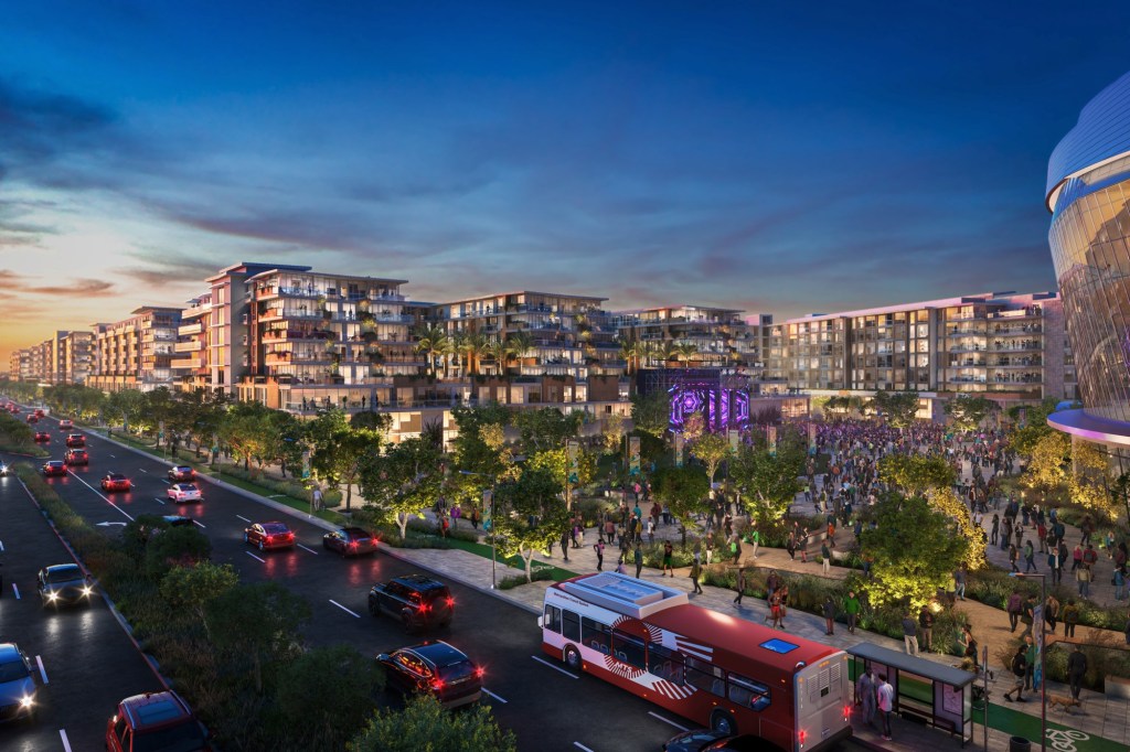
The specific plan includes 4,254 residential units, a 16,000-seat replacement arena and 130,000 square feet of commercial space, 8.1 acres of parks, and another 6.4 acres of plazas and public space on 49.2 acres of land. The team has promised to set aside 2,000 residential units for households earning 80% or less of the area median income, or what’s considered affordable housing.
The development will be built in two phases over a 10-year period, starting with the eastern portion of the site, according to the draft environmental analysis. The document identifies a construction start date in winter 2026, but delays associated with the environmental work have made that timeline infeasible, a spokesperson for the team said.
The initial phase will open with a new, 380,550 square-foot entertainment center at a max height of 165 feet and a nearly 3-acre public plaza referred to as The Square outside the venue. The first phase also includes 875 residential units in 105-foot-tall buildings and commercial space east of a new street, Frontier Drive, that bisects the site between Kurtz Street to the north and Sports Arena Boulevard to the south.
The remaining pieces will be added in a second phase that’s expected to be completed five years after the first phase, the document states. The second phases includes another north-south street, Kemper Street, the bulk of the residential units alongside a large neighborhood park called The Green and what’s left of the commercial space west of Frontier Drive.
“From the phasing perspective, the project goes east to west,” said Shelby Jordan, a project director for Midway Rising. “The primary reason for that is … to get the new entertainment center open, because that allows us to unlock the balance of the site when we have the ability to go back and demo the existing sports arena.”

The project’s traffic impacts were studied separately based on land use using vehicle miles traveled, a measurement that looks at the total miles driven by all vehicles within a specific area.
For the residential portion of the project, the vehicle miles traveled per resident will have a less-than-significant impact on transportation, the report states. The analysis, conducted by consultant Kimley Horn using various traffic models, estimates residents will travel 11.3 miles per day in 2030, 8.6 miles per day in 2035 and 10.6 miles per day in 2050, with the miles-per-resident falling below a significance threshold of 85% of the regional average of 16.1 miles.
In a separate local mobility analysis that looked at a different metric, daily trips, Kimley Horn estimates that there will be 6,573 daily residential trips in 2030, or after the completion of phase one, and 24,486 daily residential trips in 2035, or when the project is completed.
Conversely, the commercial and entertainment uses will have a significant impact on transportation, meaning there will be a net increase in vehicle miles traveled for both uses, according to the draft environmental impact report.
In 2035, there will be a regional net change in vehicles miles traveled of 24,981 miles for commercial uses, primarily related to travel to and from the project’s destination restaurants, the report states.
The analysis estimates an increase of 839,145 vehicle miles traveled per year associated with entertainment use, when comparing miles traveled to the existing arena against those associated with the future entertainment center.
In the local mobility analysis, the net new daily trips for all use types during a typical sports event or concert is pegged at 22,514 daily trips at build out.
The document identifies two mitigation measures to lessen transportation impacts.
The first measure, designed to address restaurant trips, calls for a daily shuttle to travel between the newly created Frontier Drive and the Old Town Transit Center for the first 10 years after the project opens. Although the idea is to incentive transit use, the shuttle would not reduce the commercial transportation impact to below a level of significance, the report states.
The second mitigation measure is a requirement to give arena employees a transit subsidy for the first 10 years after the project opens. The measure will lessen the entertainment-associated transportation impact to below a level a significance, according to Kimley Horn’s analysis.
The firm estimates that the employee transit subsidy will reduce the average daily vehicle miles traveled by 6,124 miles for the entertainment land use. The model assumes that 50% of 885 entertainment center employees will take transit.

The project also plans to make several changes to off-site roads and intersections to not only improve traffic flow to and from the site, but to create an environment that is conducive to walking, biking and transit.
“When you think about some of the challenges that you see along Sports Arena and Rosecrans when events occur here, it’s mainly because people all choose to come in the same way,” Jordan said. “Part of our strategy includes educating and encouraging people to now find alternate ways to access the site for events. That’s not just in their cars and the various parking structures that they’ll come to, but that’s also then tapping into other modes of transportation, namely, figuring out how to create more opportunities to drive people to the Old Town Transit Center, and then leveraging the event shuttle program … to help get people quickly from the Old Town station into the project. And what that helps to do is relieve the congestion that you see on an event basis.”
Most notably, Sports Arena Boulevard will go from a six-lane road to a four-lane road with bus-only lanes and a wide promenade fronting the project site that includes a multi-use path.
In addition, a roughly one mile stretch of Rosecrans Street, between the Old Town Transit Center and Kurtz Street, will be reconfigured from a four-lane road to a two-lane road with a center left-turn lane, bus-only lanes and a two-way, separated bikeway and sidewalk.
Kurtz Street is also slated to be redone to allow for two-way travel from Sherman Street westward to Hancock Street, and to introduce a promenade with a multi-use path fronting the project site.
When it comes to parking, the project envisions erecting its parking structures within the residential and mixed-use buildings. The specific plan calls for a total of 7,040 spaces with 4,550 spaces for residents, 2,100 spaces for entertainment center visitors and 390 spaces for store and restaurant patrons.
The setup means that Midway Rising will use off-site, overflow parking lots when events draw crowds greater than 7,500 people, the report notes.
The local mobility analysis suggests that the limited event venue parking is an intentional design choice meant to force a change in driving behavior.
“Limiting the amount of available parking has been found to encourage spectators to utilize other modes of transportation and potentially minimize the amount of traffic to be added to the roadway network,” the analysis states.
Termini said, however, that the developers designed the project with enough arena parking for today’s market, meaning there would be no change in behavior, as a percentage of visitors will naturally opt to take the trolley to the Old Town Transit Center.
But there will be some adjustments to the status quo.
“Let’s be frank, there’s been a habit of people coming to the sports arena site for 60 some odd years and parking on the front door,” Jordan said. “People are going to evolve in terms of what they’re accustomed to and what they’re used to.”
The Midway Rising project’s other significant and unavoidable impacts are linked to the demolition of the existing sports, which is a designated historical resource, and noise levels that exceed limits during special events in outdoor public areas.
Originally Published: